
The Manaslu Circuit After the Budhi Gandaki Flood: An Honest Update for Autumn 2026 Trekkers
Sunday 11 October was Ghatasthapana, the first morning of Dashain, the biggest festival of the Nepali year. Most of the country was asleep, waiting to begin ten days of family, food and flying kites. In the deep gorge of the Budhi Gandaki river in Gorkha, something let go high on a mountain in the dark, and a river with no rain in it came down like a hammer.
Here is the plain answer first, because if you are reading this you probably have flights or a deposit tied to it. The Manaslu Circuit is closed, and the trail is physically broken. The flood swept away at least six bridges and 35 to 40 houses, cut the only road into the valley, and washed the walking trail between Yaru Bagar and Jagat out of existence. Trekkers who were already up the valley were stranded and had to be flown out. Nobody can honestly give you a reopening date yet.
We are Amble Himalaya, a women-led trekking company in Kathmandu. We are writing this for the trekkers who planned Manaslu with us this autumn, and for the solo women travellers who message us every week asking whether Nepal is safe. This page will change as the facts change, and the log at the bottom shows every update with its time.
The short version, in five lines
- A landslide dam burst on a side river of the Budhi Gandaki before dawn on 11 October 2026. There had been no rain.
- The Manaslu Circuit is closed. Six or more bridges and the lower trail are gone, and the jeep road into the valley is cut in several places.
- Every trekker we know of is safe. 47 people were flown out by early afternoon, and no trekker injuries have been reported. Five local herders are missing.
- The Tsum Valley route is blocked beyond Lokpa as well.
- The rest of Nepal, including Everest and Annapurna, is open and was never touched by this flood.
What happened while Nepal slept
People living along the river woke between half past three and half past four in the morning to a sound one resident compared to a plane at low altitude, a deep continuous roar with no storm behind it. Ganesh Karki was asleep in Jagat when his phone rang before dawn. The voice on the line told him: “Brother, run! Run!” He and his neighbours climbed uphill in the dark, some still in their sleeping clothes, and watched from above as the river below them turned black with mud and rock.
The river did not rise once. It surged, dropped, and surged again, roughly six times before morning, because the thing sending it was not rain. At the gauging station in Arughat, the water stood at 2.28 metres at six in the morning. By 8:40 am it had reached 8.43 metres, and then it took the measuring station and the bridge with it. Those numbers come from the Department of Hydrology and Meteorology, and they are the cleanest way to understand how violent this was.
Here is the part that deserves to be said loudly. The people of this valley were warned in time. Police drove the riverbank settlements with loudspeakers before the worst waves arrived. The hydrology department pushed two rounds of text alerts to around 200,000 people. Villagers moved uphill in the dark, as they have learned to do, and that is why dozens of houses were lost but, as of publication, no death had been confirmed. The system worked for the people who live here. Our industry’s job now is to make it work just as well for visitors asleep in a lodge at four in the morning.
Why a river floods without rain
This is the question everyone asks, so let us answer it simply.
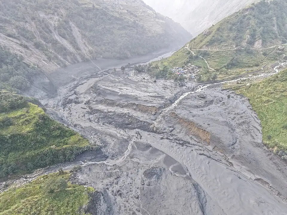
A slope of loose rock and dry earth collapsed across a small river high in the valley and sealed it shut, in the area of the Ungilung river near Chumchet. Water pooled behind the plug. Then the plug broke. The flow sealed itself again, and broke again, and each break sent another wall of black water and boulders down the gorge. The army sent a reconnaissance flight up the valley, and it confirmed a fresh dry landslide at Philim. Satellite pictures also show a large landslide in the same area. Scientists call this a landslide dam outburst flood, and the frightening thing about it is exactly what the name says. There was no rain in the catchment in the previous 24 hours, so no weather forecast could have warned anyone.
Nepal’s disaster authority initially wondered aloud whether an ice avalanche was involved. That has not been confirmed, and a team with drones and geologists went up the valley on Sunday to settle the question. Until they report, we will stick to what is verified: a landslide dam, and a river that burst out of it.
Walking up the broken valley
The easiest way to understand the damage is to walk the route in your mind, the way you would have walked it on trek.
- The trek starts here for most people, and the bridge linking the Gorkha and Dhading sides lost 22 metres of its span. No vehicles can enter the valley. Parts for a temporary Bailey bridge were being trucked from Hetauda.
- Soti Khola. The truss bridge on the jeep road is gone. The drive to Machhakhola, rough at the best of times, is finished for now.
- The bazaar that most itineraries sleep in on night one is flood damaged, and its bridge toward Kerauja is swept away.
- Khorla Besi and Dobhan. The suspension crossing and the Bailey bridge are both gone.
- Between five and seven houses were lost, and the village is cut off from both directions. The chief administrator of Chumnubri, Narayan Prasad Sapkota, said there is now no way in and no way out. One important relief: the conservation checkpoint at Jagat, the lodges and the registered trekking groups were reported safe.
- The bazaar was washed away completely, along with the construction camp of the 341 megawatt Budhi Gandaki hydropower project. Twelve project workers were flown out.
- Philim and Nyak. The bridges at the junction where trekkers branch toward Tsum Valley are gone.
- Yaru Bagar. The trail from here to Jagat has simply ceased to exist, according to the Nepal Army.
- The route beyond this village into Tsum Valley is blocked with debris.
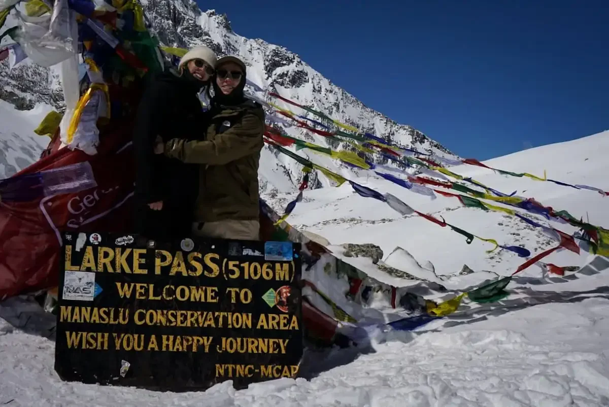
- Above Deng, Lho, Samagaun and Samdo. Undamaged, and safe, but sealed in from below. Larkya La, the 5,106 metre pass that crowns the circuit, is itself untouched. You simply cannot reach it from the south right now.
Three floods in one autumn, and why everyone is confused
If you have read three different stories about floods and Manaslu in the past month, here is the map that untangles them.
The 26 August disaster was on the Bhote Koshi and Trishuli rivers in Rasuwa, on the other side of the country. It killed around 1,400 people nationally, devastated Langtang and closed the Rasuwagadhi border. It never touched the Budhi Gandaki.
The 6 September flood hit Namrung, in the middle of the circuit, and closed the route for three days. Local people and the conservation project built a wooden bridge with their own hands, and the route reopened on 9 September. Many websites you will find today are still describing that closure as the current situation. It is not.
The 11 October flood is the one this page is about. It wrecked the lower half of the route, which September never touched. As recently as 4 October, a week before the flood, trekkers were crossing Larkya La in good autumn conditions. Whatever you read that does not carry a date after 11 October is out of date, including anything an AI chat tells you without a source.
If you are on the trail right now
If you are somewhere above the damage tonight, in Deng, Ghap, Namrung, Lho, Samagaun or Samdo, you are on the safe side of the break. Your way out down the gorge no longer exists, so the working exit is a helicopter, arranged through your trekking company or the authorities, never through a stranger with a phone number.
There is official comfort in this too. Bhuwan Ojha, the information officer of the Manaslu Conservation Area Project, said on Sunday that the tourists in the region had stayed safely in their accommodation since Saturday night, after the routes were damaged. The army flew people out from Jagat, Nyakphedi, Yaru and Payu through the day, 47 of them by early afternoon by the official count.
Do not try to cross any damaged or homemade bridge, and do not let anyone talk you into crossing on a rope. The slopes above the river are still loose, and the army has asked everyone to stay off the broken sections.
For our solo women travellers specifically: stay with your guide, stay in the lodge where people know you, and keep your phone charged and dry. Your guide is your first call. We are your second. The official emergency numbers are 1234 for the national emergency line and 1155, option 2, for the flood helpline.
What we are telling our own trekkers
We have spent today on the phone and WhatsApp with every Manaslu client we have. Here is the advice we are giving, and it works whoever you booked with.
Do not cancel Nepal. Change the plan instead. You have three honest options. Move your dates and wait for the reopening notice. Change to another region and keep your flights. Or, if only Manaslu will do, move your trek to spring, when the March to May window gives the valley time to rebuild.
Two practical things to know. Your Manaslu permits are tied to your trek dates, so if dates move, they must be reissued, and your operator should handle that early rather than at the airport. The three permits cost about 144 US dollars together in autumn, a licensed guide is required by law at a ratio of one guide to seven trekkers, and since March 2026 solo trekkers can obtain the restricted area permit alone, so you no longer need to find a second person to make a booking legal.
If you booked with us: free date change on any 2026 or 2027 departure, or transfer your deposit to any other trek, with no cancellation fee.
And if you booked elsewhere, ask your operator three questions. Is the route officially open today, not on paper but on the trail? Can I move my dates without a fee? What else can I walk on these dates if Manaslu stays shut?
Treks that are running right now
One valley is broken. The rest of the country is having a beautiful autumn. These are all running normally:
- The Annapurna Base Camp trek, eight days of rhododendron forest and a natural amphitheatre of peaks.
- The Annapurna Circuit, if you want a long walk with a high pass, which is the closest in spirit to what Manaslu offers.
- The Everest Base Camp trek, thirteen days in the Sherpa homeland.
- Mardi Himal, a short, gentle ridge walk that many of our solo travellers love.
- Langtang Valley and Gosainkunda, closer to Kathmandu. Both were touched by the August flood on the Rasuwa side, so ask us about trail conditions on your exact dates before you commit.
If Manaslu itself is the dream, hold it. The circuit has closed and reopened before, the people of this valley rebuild fast, and spring is a genuinely lovely time to walk it. Our Manaslu Circuit trek page keeps the full itinerary, and our guide to the best time for Manaslu explains the spring window in detail.
The women who keep these trails alive
We want to add one thing that matters to us as a women-led company. In many villages of the Budhi Gandaki valley, men travel abroad or to the cities for work for months at a time, and it is the women who run the teahouses, cook the dal bhat, raise the children and keep the trail economy breathing. Anyone who has walked this circuit knows their faces.
When a season stops, those women feel it first and hardest. Some of them lost their houses on Sunday. The fastest help any of us can give is to keep booking Nepal, to book through companies that hire locally, and to come back to Manaslu the moment it reopens. The first rescuers on Sunday were not flown in. They were the guides, porters and lodge staff who live there.
How to help from anywhere
- Keep your Nepal trip, wherever in Nepal it is. Cancellation hurts the wrong people.
- If you want to give money, give through the Chumnubri and Dharche municipal offices or the official NDRRMA channels. Write to us and we will tell you which channel is active on the day you read this.
- Do not forward unconfirmed numbers. In the first hours of a disaster, the figures change hourly and wrong ones travel faster than right ones.
Your questions, answered
Can I still trek the Manaslu Circuit this October or November?
No. The lower trail and the bridges are gone, and the road into the valley is cut. Trekking can only restart after repairs and an official safety clearance from the Gorkha authorities. Watch this page for that notice.
Is Manaslu closed for the rest of 2026?
Nobody knows yet, and anyone quoting a reopening date is guessing. The smaller September break was bridged in three days. This damage is far larger and falls inside the Dashain holidays, so repairs will move slowly for a week or so.
Were any trekkers hurt or killed?
No trekker injuries or deaths have been reported. Trekkers were stranded and evacuated, not caught in the water. The five people missing as of publication are local herders from a shelter in Chumchet, and several more herders were out of contact in the early counts.
What about Tsum Valley?
Blocked as well. The route beyond Lokpa is obstructed, and the bridges at the Philim junction, which every Tsum itinerary crosses, are gone.
What caused the flood?
A dry landslide dammed a tributary of the Budhi Gandaki and the water broke through repeatedly, according to the police, the army and the hydrology department. There was no rain. A drone and geology team is verifying the exact trigger.
Is Nepal safe for trekking this autumn?
Yes. One valley in one district was hit. Everest, Annapurna, Mustang, Kanchenjunga and the far west are all open and operating normally, and October and November are the best walking months of the year.
What happens to my money if I change plans?
Ask your operator before you cancel anything. Most companies, including us, would rather move your dates or transfer your deposit to another trek than lose your trip to Nepal entirely.
Where our information comes from
We update this page only from official sources: the disaster authority NDRRMA, the Department of Hydrology and Meteorology, the District Administration Office in Gorkha, the Manaslu Conservation Area Project, the Nepal Army and the Department of Roads. We cross-check against the reporting of the Kathmandu Post, Everest Chronicle and The Himalayan Times, and we attribute every number to the person or office that reported it. Our Manaslu region guide covers the route itself for whenever you are ready to plan the walk.